Secret Viewpoints: Escape the Crowds, Discover Trending Hidden Gems (Your Ultimate Guide to Unfiltered Beauty)
I love a good view. Who doesn't? That heart-stopping moment when the world opens up beneath you, painting a masterpiece you feel privileged to witness. But let's be honest: that magic often gets diluted when you're elbow-to-elbow with hundreds of other tourists, all vying for the same photo op. I've been there, trust me. Stood in line for an hour just to catch a glimpse of a famous landmark, only to find my view obstructed by a sea of phones. It’s a buzzkill, pure and simple.
For years, I've made it my personal mission to sniff out those elusive spots – the ones that deliver all the grandeur, all the awe, but none of the crowds. And lately, something exciting has been bubbling up. A new wave of discerning travelers, just like us, are seeking out these secret viewpoints before they hit the mainstream. They’re trending not because they’re advertised on every billboard, but because they offer an authentic, unadulterated experience. They’re the places where you can actually hear the wind, feel the vastness, and snap a truly unique, Instagram-worthy shot without a stranger's head in the frame.
I'm talking about the kind of places you stumble upon (or, more accurately, meticulously research and trek to) that make you feel like you’ve unlocked a cheat code to travel. The kind of places that make your friends say, "Where is that?!" when they see your photos.
So, ditch the guidebooks, forget the usual suspects, and let me take you on a journey to six of these phenomenal, zero-crowd viewpoints that are quietly but powerfully trending right now. These aren't just pretty spots; they're experiences that will redefine your idea of scenic beauty. Ready to feel like a true discoverer? Let’s dive in.
---
1. The Zion Revelation: Observation Point (via East Mesa Trail), USA
Location:
Zion National Park, Utah, USA
Why it's trending: The ultimate Angels Landing alternative for solitude seekers.
Crowd Factor: Minimal on the East Mesa Trail, especially if you start early.
My first trip to Zion National Park was awe-inspiring, but also a bit… overwhelming. Angels Landing, as iconic as it is, felt more like a human conveyor belt than a spiritual ascent. I craved that quintessential, sweeping canyon view without the constant hum of conversation and the jostle for space. A park ranger, sensing my frustration, leaned in conspiratorially and whispered, "If you want the real view, the one above Angels Landing, take the East Mesa Trail to Observation Point."
And so, my quest began. This isn't the direct (and currently closed due to rockfall) route from the main canyon floor; this is the backdoor route, a longer but significantly less strenuous hike that rewards you with an unparalleled perspective. We started our trek from the East Mesa Trailhead, which requires a bit of planning (either a shuttle service from Springdale or a 4x4 if you dare the unpaved road). The trail itself is a gentle, shaded walk through pine forests, a stark contrast to the exposed, sheer cliffs of the main canyon. For about 6-7 miles (round trip), we walked mostly in silence, passing only a handful of other hikers.
Then, it happened. We emerged from the forest, and the world just dropped away. Observation Point. The sheer scale of Zion Canyon unfolded before us, a breathtaking panorama of red rock, verdant valleys, and the Virgin River snaking below. Angels Landing, that famous, intimidating fin of rock, was now below us, a tiny speck in the grand scheme of things. The silence was profound, broken only by the whisper of the wind and the distant cries of birds of prey. I sat there for what felt like an eternity, absorbing the view, taking photos that truly captured the immense beauty without a single person in the frame. This isn't just a viewpoint; it's a moment of pure, unadulterated triumph.
Practical Tips for Your Zion Revelation:
* Getting There: The East Mesa Trailhead is located outside the main park entrance. Most people use a shuttle service from Springdale (look up "East Mesa Shuttle Zion") which will drop you off and pick you up. Alternatively, if you have a high-clearance 4x4 and confidence, you can drive to the trailhead (check road conditions first!).
* Best Time: Spring and Fall offer pleasant temperatures. Start early in the morning to beat any potential heat and enjoy the soft light for photography.
* What to Bring: Ample water (no refilling stations on the trail), snacks, sturdy hiking shoes, sun protection, and your best camera.
* Permits: No permit required for the East Mesa Trail to Observation Point.
---
2. Norway's Untamed Crown: Segla, Senja
Location:
Senja Island, Troms og Finnmark, Norway
Why it's trending: A dramatic, fjord-side peak offering iconic views, a less-crowded alternative to Lofoten.
Crowd Factor: Moderate, but far less than Lofoten hotspots. You’ll have plenty of space.
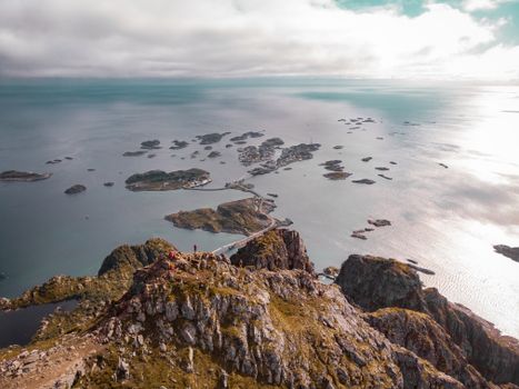
My journey to Senja was driven by a single image I'd seen online – a jagged, almost impossibly steep mountain rising directly from a fjord, bathed in the ethereal glow of the Arctic sun. I’d done Lofoten, and while stunning, the sheer volume of photographers at every iconic spot had left me yearning for something more raw, more solitary. Senja, Norway’s second-largest island, promised just that, and Segla was its crown jewel.
The hike to Segla is not for the faint of heart, but it’s incredibly rewarding. The trail begins near the small village of Fjordgård, and it’s a steep, unrelenting climb of about 600 meters (1,970 feet) over 2.5 kilometers (1.5 miles). As I ascended, the views of the surrounding fjords, including the famous Hesten peak (which offers the classic Segla profile shot), became increasingly breathtaking. The air was crisp, carrying the scent of pine and the fresh sea spray.
Reaching the summit of Segla felt like standing on the edge of the world. The panoramic vista encompassed the deep blue of the fjord below, the patchwork of green and brown mountains, and the endless expanse of the Arctic Ocean. I spent a long time just sitting there, dangling my feet (carefully!) over the edge, feeling the immense power of nature. There were only a handful of other hikers, all equally mesmerized, speaking in hushed tones. It’s a place that commands respect and offers an unparalleled sense of achievement. The photos I captured here – the sheer drop, the dramatic light, the sense of isolation – are some of my most cherished.
Practical Tips for Your Senja Adventure:
* Getting There: Fly to Tromsø (TOS), then either rent a car and drive (about 3-4 hours, including a ferry) or take a bus. A car is highly recommended for exploring Senja.
* Best Time: Mid-June to mid-September for hiking. August and September offer beautiful autumn colours and fewer mosquitoes. For the Midnight Sun, visit in June/July.
* What to Bring: Layered clothing (weather can change rapidly), waterproofs, sturdy hiking boots, snacks, and plenty of water. Trekking poles are highly recommended for the descent.
* Accommodation: Fjordgård has limited options; consider staying in Mefjordvær or Hamn i Senja for more choices.
* Photography: For the iconic shot of Segla, hike Hesten (the adjacent peak). For the view from Segla, just climb Segla!
---
3. Balinese Serenity: Pinggan Village Sunrise Viewpoint, Indonesia
Location:
Kintamani region, Bali, Indonesia
Why it's trending: A peaceful, authentic alternative to crowded Mount Batur sunrise treks.
Crowd Factor: Very low. You'll likely share it with only a few other early birds.
Bali is beautiful, no doubt. But the sheer volume of tourists at popular spots like Campuhan Ridge Walk or the main Mount Batur trek can sometimes detract from the island's spiritual serenity. I was determined to find a sunrise spot that offered that iconic volcano view without the clamor. A local friend, a true Balinese gem, suggested Pinggan Village. "It's a little out of the way," she said, "but the quiet is worth it."
She wasn't wrong. This viewpoint isn't a marked tourist attraction; it's simply a stretch of road near Pinggan village in the Kintamani highlands, known to local guides and a select few photographers. We left Ubud at 3:30 AM, driving through the pitch-black Balinese countryside, the air growing cooler as we ascended. There were no signs, no bustling warungs selling breakfast; just the quiet hum of our scooter and the faint chirping of awakening birds.
As we parked on the side of the road, the sky was a deep indigo. We found a small, grassy patch overlooking a vast valley. In the distance, the majestic silhouettes of Mount Batur and Mount Agung began to emerge from the inky darkness. Slowly, imperceptibly at first, the horizon bloomed with fiery oranges, soft pinks, and vibrant purples. Mist swirled in the valley below, creating an ethereal, cloud-like blanket that eventually parted to reveal the patchwork of rice paddies and villages.
Watching the sun kiss the peaks of the volcanoes, painting the sky in ever-changing hues, was a profoundly peaceful experience. There were maybe five other people scattered along the road, all equally hushed, just soaking it in. We even found a small, makeshift coffee stall set up by a local farmer, serving hot cups of Balinese coffee as the world woke up around us. It was authentic, breathtaking, and utterly devoid of the usual tourist hustle. This is the Bali I came for.
Practical Tips for Your Balinese Sunrise:
* Getting There: You'll need a scooter or a private driver. It's about a 1.5-2 hour drive from Ubud. Use Google Maps and search for "Pinggan Village Sunrise Viewpoint" or "View Point Mount Batur Pinggan."
* Best Time: Obviously, sunrise! Aim to arrive at least 30-45 minutes before sunrise to catch the pre-dawn colors.
* What to Bring: Warm layers (it gets chilly at altitude before dawn), a blanket or sarong to sit on, a thermos of hot tea/coffee if you're not relying on a local vendor, and your camera.
* Respect: This is a local area. Be quiet, respectful, and consider buying coffee from local vendors if available.
* Combine With: After sunrise, you can explore the Kintamani area, visit a coffee plantation, or head to the nearby Batur Natural Hot Spring.
---
4. Madeira's Mystical Gateway: Miradouro da Ribeira da Janela, Portugal
Location:
Ribeira da Janela, Madeira, Portugal
Why it's trending: A dramatic coastal viewpoint showcasing unique sea stacks, less-visited than other island icons.
Crowd Factor: Low to moderate. You’ll find parking and space, even on busy days.
Madeira, the "Pearl of the Atlantic," has been buzzing lately, and for good reason. Its dramatic landscapes, lush levada walks, and breathtaking cliffs are pure magic. But with popularity comes crowds, and spots like Pico do Arieiro can get quite busy. On a recent road trip around the island, searching for that perfect, wild coastal shot, we stumbled upon something truly special: Miradouro da Ribeira da Janela.
Located on the rugged north coast, just west of Porto Moniz, this viewpoint isn't a high mountain peak but a mesmerizing coastal spectacle. What makes it unique are the two enormous, ancient rock formations (sea stacks) that stand defiantly in the crashing Atlantic waves, just offshore. They've been sculpted over millennia by the relentless power of the ocean, creating a natural archway and a striking silhouette.
We pulled into the small parking area, and a short, easy walk took us to the viewing platform. The wind whipped around us, carrying the invigorating scent of the sea. Below, the waves roared against the rocks, sending spray high into the air. The view was raw, untamed, and utterly captivating. It felt ancient, like gazing upon a landscape that had existed unchanged for eons. While other viewpoints boast panoramic island views, Ribeira da Janela offers a powerful, intimate connection with the ocean's grandeur. There was a sense of profound peace here, watching the interplay of rock, water, and sky. It’s a photographer's dream, especially at sunrise or sunset when the light paints the sea stacks in golden hues.
Practical Tips for Your Madeira Discovery:
* Getting There: Renting a car is essential for exploring Madeira's north coast. The viewpoint is easily accessible directly from the ER101 coastal road.
* Best Time: Any time of day offers stunning views, but sunrise or sunset can be particularly magical for photography. Check tide times if you want to venture closer to the water (there’s a small tunnel leading to a pebble beach).
* What to Bring: Windbreaker/jacket (it can be breezy), good walking shoes if you explore the beach, and your camera.
* Combine With: Explore the natural volcanic swimming pools of Porto Moniz nearby, or continue along the scenic north coast road towards Seixal and São Vicente. Don't miss the Fanal Forest for a completely different mystical experience.
---
5. Seoul's Sky-High Secret: Bukhansan National Park (Baegundae Peak), South Korea
Location:
Seoul, South Korea
Why it's trending: A challenging urban escape with unparalleled city-meets-nature views, popular with active locals.
Crowd Factor: Popular with Koreans, but surprisingly few international tourists compared to other Seoul attractions.
Seoul is a dazzling, dynamic metropolis. From the neon glow of Myeongdong to the historic charm of Gyeongbokgung Palace, there's always something to see and do. But sometimes, even in the most exciting cities, you crave an escape, a chance to breathe and gain some perspective. That’s where Bukhansan National Park comes in – a granite mountain range that literally sits within the city limits. While many tourists flock to Namsan Tower for city views, I opted for a more challenging, and ultimately more rewarding, ascent to Baegundae Peak.
My Korean friend, an avid hiker, insisted this was the real Seoul experience. "You'll see the whole city, but also feel completely immersed in nature," she promised. The hike to Baegundae Peak (the highest point in Bukhansan) is no stroll in the park. It’s a strenuous 3-4 hour climb (one way) involving steep inclines, rocky paths, and even some sections with fixed ropes and chains, especially as you approach the summit.
As we ascended, the urban sprawl slowly gave way to dense forests, ancient temples tucked into valleys, and dramatic granite formations. The air grew fresher, and the sounds of the city faded into a distant hum. Reaching Baegundae Peak was exhilarating. From the top, the panoramic view was utterly spectacular: the sprawling urban landscape of Seoul stretching to the horizon on one side, and the rugged, forested peaks of Bukhansan National Park on the other. It was a powerful reminder of how nature and modern life coexist in South Korea. We shared the summit with a handful of enthusiastic Korean hikers, all enjoying their packed lunches and the incredible vista. It felt like we had earned this view, a secret shared among those willing to put in the effort.
Practical Tips for Your Seoul Summit:
* Getting There: Easily accessible by Seoul Metro. Take Line 3 to Gupabal Station (Exit 2) and then a short bus ride (Bus 704 or 34) to Bukhansanseong Fortress Entrance.
* Best Time: Spring (April-May) for cherry blossoms and mild weather, or Autumn (September-October) for stunning fall foliage. Avoid peak summer if you're sensitive to heat and humidity.
* What to Bring: Proper hiking boots (the terrain is rocky), plenty of water, snacks/lunch, sun protection, and layered clothing. Gloves can be helpful for the chain sections near the peak.
* Gear Rental: If you don't have proper hiking gear, there are sometimes small shops near the park entrance that rent out poles or even shoes.
* Food: Pack a lunch to enjoy at the summit, or grab a traditional Korean meal at one of the restaurants near the park entrance after your hike.
---
6. Australian Grandeur, Unfiltered: Govetts Leap, Blue Mountains, Australia
Location:
Blue Mountains National Park, New South Wales, Australia
Why it's trending: A less-crowded, equally stunning alternative to the Three Sisters, offering vast canyon and waterfall views.
Crowd Factor: Low. You'll find peaceful solitude here, even on weekends.
The Blue Mountains, just a short drive from Sydney, are renowned for their dramatic escarpments, eucalyptus forests, and the iconic Three Sisters rock formation. And while the Three Sisters are indeed impressive, the viewing platforms at Echo Point can get absolutely swamped, especially during peak season. I was looking for a spot that offered that quintessential Blue Mountains grandeur – vast canyons, misty valleys, and cascading waterfalls – but with a sense of peace and discovery. A local friend, a true Blue Mountains aficionado, pointed me towards Govetts Leap.
"It's bigger, bolder, and you won't be fighting for a photo," he assured me. He was right. Govetts Leap, near Blackheath, is a hidden gem that feels worlds away from the tourist bustle of Katoomba. We drove through charming mountain towns, the air growing cooler and smelling distinctly of eucalyptus, until we arrived at a well-maintained but quiet parking area.
From the main lookout, the view is simply astounding. The vast Grose Valley stretches out before you, an immense chasm carpeted in a blue haze (hence the name "Blue Mountains"). To your left, the magnificent Govetts Leap Falls plunge 180 meters (590 feet) into the valley floor, a silver ribbon against the dark rock. The sheer scale of the landscape is breathtaking, feeling much more expansive and wild than the more confined views at Echo Point. I spent ages just watching the clouds drift over the valley, the light playing tricks on the cliffs, and listening to the distant roar of the waterfall.
For those wanting to explore further, there are several walking tracks from Govetts Leap. We took a short, easy stroll along the cliff edge to another viewpoint, Horseshoe Falls, which offered a different perspective of the valley. The solitude was profound, allowing for true contemplation of this ancient, majestic landscape. It's the kind of place where you can truly connect with nature and forget the world for a while.
Practical Tips for Your Blue Mountains Escape:
* Getting There: Govetts Leap is about a 1.5 to 2-hour drive west of Sydney. Take the M4 motorway, then the Great Western Highway. It's well signposted from Blackheath.
* Best Time: Spring (Sept-Nov) for wildflowers and mild weather, or Autumn (March-May) for crisp air and beautiful foliage. Avoid summer if you prefer cooler temperatures.
* What to Bring: Comfortable walking shoes, water, snacks (there are no shops at the lookout), sun protection, and a light jacket as mountain weather can be unpredictable.
* Combine With: Explore the charming village of Blackheath, visit the stunning Rhododendron Gardens, or embark on one of the many other walking trails in the Grose Valley. For a unique experience, consider visiting the Blue Mountains Botanic Garden Mount Tomah on your way back to Sydney.
---
Your Next Adventure Awaits: Ditch the Crowds, Embrace the Unseen
There you have it – six incredible viewpoints that promise not just stunning vistas, but also an authentic, crowd-free experience. These aren't just places; they're invitations to step off the well-trodden path, to put in a little extra effort, and to be rewarded with moments of pure, unadulterated beauty.
Remember that feeling of discovering something truly special, something you almost want to keep just for yourself? That's the magic of these trending hidden gems. They're about more than just a photo; they're about the journey, the solitude, and the profound connection you make with the world when you experience it on your own terms.
So, what are you waiting for? Pick a spot, pack your bags, and get ready to create memories that will truly stand out. Have you discovered a secret viewpoint that blew your mind? Share your stories and tips in the comments below – let's keep this community of intrepid travelers growing!
Which of these secret viewpoints are you adding to your travel bucket list first? Let us know in the comments and tag #TripsoraSecrets when you post your crowd-free snaps! Happy travels!
---